In this article, I’ll describe a prospecting trip in late September, 2009 that took me to several different locales. I can update you on some of the road conditions, and maybe give you a few ideas of your own. The major producer in this general area was the Monte Cristo district, mostly wrapped up in the Alpine Lakes Wilderness Area and off-limits. So we hit it briefly, then concentrated on the next drainage south, along the Skykomish River, including Beckler River, Foss River, Miller River, Money Creek, the Sultan River, and the North Fork of the Skykomish.
Background
First, let’s understand where the area fits into historic gold mining in Washington, by consulting “old reliable” – U.S. Geological Survey Bulletin 610:
“Gold was first discovered in the state in 1853 in the Yakima River valley by a party under the command of Capt. George McClelland exploring for a possible railroad route (Huntting, 1955, p. 28). By 1855, prospectors were active in the Colville district, although the first discoveries were not made until 1883. In 1855, small placers were found along the Columbia and Pend Oreille Rivers. From the 1850s through the 1890s, placers were worked along streams in Okanogan, Whatcom, Chelan, and Kittitas Counties and along the major streams of the state – the Columbia and Snake Rivers. By 1900, however, most of the placer deposits were exhausted.” (Koschmann and Bergendahl, 1968, p. 260)
For Snohomish County, the authors have a little more detail of interest:
“In south-central Snohomish County gold was produced from several districts in the western part of the Cascade Range. These districts – Monte Cristo, Index, Silverton, Silver Creek and Sultan—are more or less contiguous and occupy an area about 10 miles wide and 20 miles long extending from about the center of the county south to the King County boundary…The Monte Cristo and Silverton districts produced most of the gold in the county. Patty (1921, p. 282) estimated that the combined early production of all metals, but mostly gold, from these districts was worth $7 million. From 1903 through 1956, production was 9,595 ounces of lode gold and 535 ounces of placer gold.
“Spurr (1901, p. 804-805) believed that ore deposition began in late Pliocene or early Pleistocene and continued to the Recent. The most important deposits are mineralized joints within or near tonalite masses. Ore minerals are galena, sphalerite, chalcopyrite, pyrite, and arsenopyrite. An upper zone, with is nearest the surface, contains galena, sphalerite, and chalcopyrite and is richer in gold and silver…” (p. 261)
So what does that mean? Basically, you’re looking for sulphides, including fool’s gold, or pyrite. Western Washington’s incessant rain will turn sulphides veins black by liberating sulphur, and sometimes you can even sniff out a pyrite-rich zone.
Here’s a rough map of the major gold areas we’re talking about, taken from the Gold Digger’s Atlas:

Figure 1. Gold districts near Stevens Pass, WA. Cick it to make it larger.
Monte Cristo
| Area | Monte Cristo |
| GPS reading | 48.01887, -121.44429 |
| Land Status | US Forest Service |
| Activity | Panning |
| Warning(s) | Active claim near road; Old mines on private land |
| Waterway | South Fork Sauk River |
| Nearest town | Darrington |

Figure 2. Mountains near Monte Cristo.
The simplest way to reach Monte Cristo is to drive south from Darrington on the Mountain Loop Highway, which is actually a gravel road in its more remote stretches. There is plenty of camping in the area, with primitive spots throughout but also organized camps, especially out of Verlot. At Barlow Pass, you’ll usually spot many cars parked along the road near the trail head. Be sure to lock your valuables. You’ll need to hike about a half-mile, as there is an active claim along the S. Fk. Sauk River.
This GPS reading is right on the road; it’s the best early place to hike down to the water on the easy, level trail. There is a big jumble of mossy boulders; go a little further, and you should locate a trail to the river that is short and doesn’t take you through the underbrush. Gravels are extensive here. Look for traps up and down the river. Rockhounding material includes gneiss, schist, quartz, granite, marble, etc. We chose a spot at the head of a big gravel bar and found good black sand in the first pan, and color in the second pan. The quantity of the black sand and the size of the colors increased with depth. Fill in your big holes.
There are mines everywhere in the hills above the ghost town, but most are private. It’s a gorgeous area, great for a day hike to the town site of Monte Cristo, now barely recognizable. Rockhounds talk about decent quartz crystals at high elevation above Monte Cristo. We took a detour up to a famed garnet collecting area on Sloan Creek, out of Bedal, but the road was washed out and we ended up collecting small garnets until we lost the battle with horse flies near the Sloan Creek trail head.
Traffic gets heavy along this scenic highway during the summer, and many tight passing spots along the loop are dangerous. Not all drivers are as courteous as you’d like them to be. Heavy rains have washed out this road in the past, and there is no way to predict if the road will always be open; be sure to email or phone the Snoqualmie-Baker National Forest at Darrington any time you plan a trip up here.
Beckler River
| GPS reading | 47.73496, -121.33371 |
| Land Status | US Forest Service |
| Activity | Panning for small garnets |
| Warning(s) | None |
| Waterway | Beckler River |
| Nearest town | Skykomish |
The rest of the locales in this article are south of Monte Cristo, in the Skykomish drainage. We camped in the Beckler River campground, a very nice spot with no road noise from US Highway 2. An outcrop of garnet schist up river from the camp provides lots of garnets in the river gravels, and a little black sand, but we didn’t pull any colors from this locale.
A few years ago, the road looped from Skykomish, up Beckler River, then down to the Index area and back to Highway 2. In 2009, we ran into a sign that indicated the road was open only to local traffic when we were closing in on the old Galena area mines. This means that there is no public access to the Silver Creek district, which is a shame. On the other side of the loop, just outside of Index, the main road to Galena and Silver Creek is badly washed out, also preventing access. It’s a pity, because there is probably a good opportunity to pan from Silver Creek, and anyone interested in a challenging alpine hike can actually reach Monte Cristo by hiking up Silver Creek and across Poodle Dog Pass. Hopefully the road situation will improve in the future if there are enough forests to log up there.
Foss River
| GPS reading | 47.63053, -121.30924 |
| Land Status | US Forest Service |
| Activity | Limited panning |
| Warning(s) | None |
| Waterway | Foss River |
| Nearest town | Skykomish |
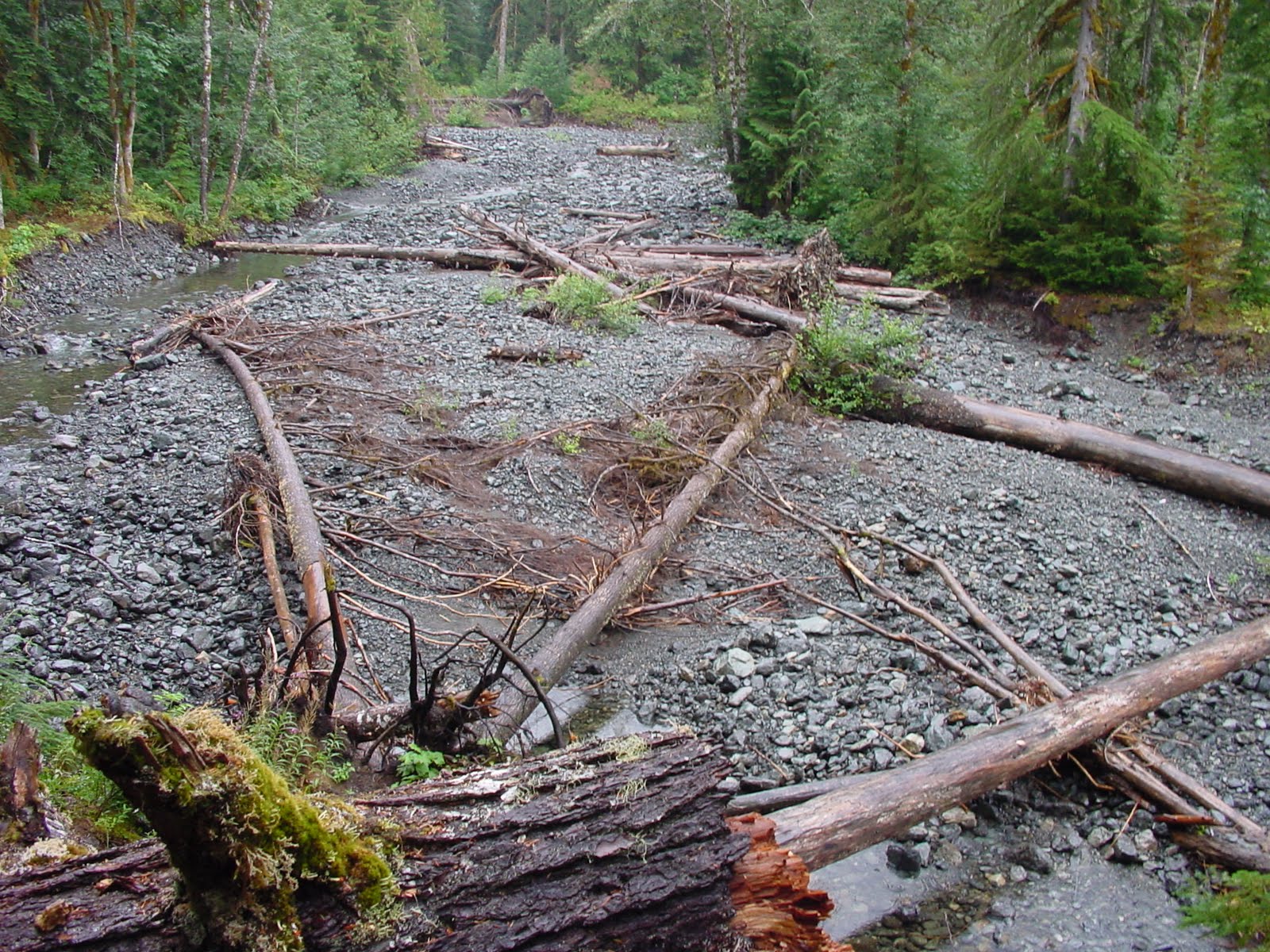
Figure 3. Foss River flood zone.
About two miles east of Skykomish (which has gas and a liquor store) the Foss River Road heads south into the steep mountains. We followed it (also known as NFD 68) for about 6.5 miles, until it dead-ended at the trailhead. There are two old mining claims along the Foss River that date from decades ago, located below Trout Lake. There were hard rock mines around Trout Lake, but the area is accessible only via hiking trail. We walked in a little less than a mile and found a likely spot on the river, but the panning wasn’t that great. We pulled a little black sand, but nothing to brag about, and not enough color to spur us to look harder or longer. Honestly, the area looked like it had witnessed a horrific flood, and most of the small sand was blown away. Before I completely cross it off the list I’d want to hike all the way to the old mines at Trout Lake, but it isn’t high on my list.
Miller River
| GPS reading | 47.71073, -121.39742 |
| Land Status | US Forest Service |
| Activity | Panning, sluicing |
| Warning(s) | None |
| Waterway | Miller River |
| Nearest town | Skykomish |

Figure 4. Entrance to the Mohawk Mine, near the Miller River.
To reach a good panning spot on Miller River, head west from Skykomish along the Old Cascade Highway about 2.3 miles until you see a left turn, south, on Miller River Road. This is NFD 6410. You’ll join up with the Miller River after less than a mile, and you can start looking for river access. Alternatively, you can turn off of US Highway 2 at the Money Creek campground turnoff, and you’ll see the turn onto Miller River Road after a mile.
We found good gravel bars that contained a tan-brown jasper, and some of it was so swirly that it is called picture jasper. What interested us were the boulders covered with moss, which we sampled with excellent results. There are also several decent bedrock traps, where the black sand was excellent, and the colors got better with depth. Unfortunately, the boulder we were carving under shifted and nearly claimed a miner, so we retired for lunch and moved on. Nobody said it was going to be easy.
Later, we hooked up with Daryl Jacobson of the group Northwest Underground Explorations. They’ve written three books on Washington underground mines, and each is a fabulous resource. Daryl helped us find the trail up to the Mohawk Mine, which was a small prospect along the Miller River. His group had been out recently, and there was flagging along the dim trail, so we easily found the entrance. The miners were apparently chasing a vein of blackened sulphides, and we got a couple samples before leaving.
There is excellent primitive camping throughout the area along Miller River, and the developed Money Creek campground is good, but has a little too much road noise for my tastes.
Money Creek
| GPS reading | 47.70719, -121.44274 |
| Land Status | US Forest Service |
| Activity | Panning, sluicing, etc. |
| Warning(s) | none |
| Waterway | Money Creek |
| Nearest town | Skykomish |

Figure 5. Mossy boulders along Money Creek.
This was the best spot of the bunch, which must be why it’s called Money Creek. To reach our spot, turn off US Highway 2 at Money Creek, go past the campground, over the railroad tracks, and about a mile from US 2, look for the sign for Miller River. As soon as you turn onto Miller River Road, look for Money Creek Road. This is NFD 6420. Take it for about 2.3 miles to reach our spot, but you can stop anywhere creek access looks likely.
We found more of the tan picture jasper in Money Creek, and petrified wood is reported from the gravels in this area. There is bedrock here, which makes for excellent gravity traps, and the moss mining and crevicing was fantastic. The black sand was abundant, and we got color with the first pan. Again, there is good primitive camping all along the creek, and the developed Money Creek campground is OK, just close to US 2.
If the road isn’t washed out, the Washington State Mineral Council used to mount an annual expedition to the Damon & Pythias Mine on NFD 6422. If you enjoy going underground, your best option is to hook up with WSMC because they get the right keys to the right gates and get to swing their picks in the mine itself. There is nothing like seeing a little pinpoint of daylight at the end of a long mine tunnel, if you’ve never experienced that sensation.
Sultan County Park
| GPS reading | 48.01887, -121.44429 |
| Land Status | US Forest Service |
| Activity | Light panning |
| Warning(s) | No dredging in the park |
| Waterway | Sultan River |
| Nearest town | Sultan |
Because the water was low and there wasn’t much going on, we stopped at the county park right on the Sultan River, practically in “downtown” Sultan. Take Albion Street north into the park, and angle over to where the river forms a nice elbow. There is an impressive little gravel bar there, and for many folks, this is about as close as you’re ever going to get to the Sultan placers. Since it’s a park, we didn’t go crazy, but we dug a couple holes on the inside bend of the elbow and panned out a lot of black sand before the rain drove us off. This is one of those spots where you might draw a crowd, you’d have to fill in your holes completely, and you might even make a good show of picking up some litter.
The problem with the Sultan River is access. We wanted to hook up with the Washington Prospectors and have them show us around the Sultan basin, but we managed to choose one of the wettest weekends of the year, so those plans fell apart. Way back when I was in graduate school at the University of Washington my wife signed me up for a non-credit gold panning class as a birthday gift. The class met at Horseshoe Bend, on the Sultan River, below the canyon and the dam. It’s on private utility land, and was open back then, but for the last ten years Horseshoe Bend has been off-limits. The spot was listed in old GPAA Claims Guides in the mid-1990s, but again, it is no longer open.
In fact, the best spots on the Sultan are claimed up by the big Washington club, and they wince every time the local magazines and newspapers write a story about weekend panners and the high price of gold. The inevitable result is that too many folks come out, end up getting lost or confused, accidentally trespass or claim jump, and generally cause problems. So I didn’t even stray up the Sultan, and I don’t advise that you do, either, unless you join the club first.
Sultan Bridge
| GPS reading | 47.86002, -121.81380 |
| Land Status | US Forest Service |
| Activity | Panning |
| Warning(s) | Bit of a hike |
| Waterway | Skykomish River |
| Nearest town | Sultan |

Figure 6. Short beach near Sultan bridge.
Barring access to the Sultan River itself, you can do some decent panning around the point where the Sultan dumps its load near the Sultan Bridge. You should be able to spot a fisherman’s access and parking area just across the Skykomish River from Sultan. At 5th Street, cross the river on Ben Howard Road, but once you reach the other bank, look for the parking area. There are two trails from the lot – one goes more or less northeast, while the other goes northwest. We tried the northeast route first and reached a steep bank with a small beach, and what looked like the pilings to an old bridge. Just for grins, we scraped some moss into a plastic bag someone had littered, and when we got it back to camp, we washed the moss in a five-gallon bucket and poured a good sample into a pan. The pan held a nice showing of black sand and a fine line of tiny gold pinpoints.
If you go on the other trail, which is longer, you can access a gravel bar directly across the Skykomish from the mouth of the Sultan River. The bedrock isn’t accessible, so you’re limited to float gold trapped in the gravels, or more moss mining.
Skykomish River
| GPS reading | 47.84517, -121.92648 |
| Land Status | US Forest Service |
| Activity | Panning, crevicing |
| Warning(s) | Fishing spot |
| Waterway | Skykomish River |
| Nearest town | Monroe |

Figure 7. Bedrock along the south shore of the Skykomish River near Monroe.
Because so many mines dot the hills above the Skykomish River, and gold enters in from the Sultan River, Miller River, Foss River, North Fork of the Skykomish, and Money Creek, we gave the big river a chance outside of Monroe. To reach this spot, from Monroe drive south on Lewis Street, which is also WA 203, for a mile until you reach Ben Howard Road. Take Ben Howard for about 2.1 miles until you spot the fisherman’s access point.
This public access spot has a bedrock outcrop at the upper end, and it’s covered with moss. There are gravity traps in the crevices that replenish constantly. The gravel bar itself can be crowded with fishermen during the fall season, but when its less occupied, you can rockhound the gravels for lots of interesting material for the tumbler.
Summary
The Steven Pass area has a lot more mining history than you might think. We sampled from multiple spots in a fascinating three-day tour, then set up a few of our panning machines in camp to figure out which area was best. Hands down, Money Creek was the winner. We ended up with the best colors and the most black sand from Money Creek, but Miller River wasn’t bad. The Sultan is promising, and spots on the Skykomish, such as the Gold Bar area, or our bedrock discovery near Monroe, were decent enough.
The Washington State Department of Natural Resources wants you to have a “Gold and Fish Pamphlet” with you whenever you pan, but the good news is that they finally relented and you can pick it up off their website, rather than get it mailed to you. Without the pamphlet, you can get a ticket, so be sure to follow up with the links below.
Links
Department of Natural Resources
Info on collecting, plus the home of the infamous Washington minerals checklist.
http://wdfw.wa.gov/habitat/goldfish/
Geology Adventures
Bob Jackson leads Washington field trips for newcomers and experts alike, priced accordingly. If you liked Hansen Creek, try Spruce Ridge or Big Rock Candy Mine.
National Forest pages
Crucial for road and fire information; always good to check in before you visit. Links to all Washington and Oregon forest offices.
http://www.fs.fed.us/r6/r6nf.htm
Washington Geology Maps
Those pretty colored maps that show the bedrock geology. Interactive; describes formations.
http://wa_geology.home.comcast.net/
Washington Prospectors Mining Association
Energetic group with tons of gold knowledge. Plus, they own their own claims.
http://www.washingtonprospectors.org/
Washington State Mineral Council
The grand-daddy of all Washington rock clubs.
http://www.mineralcouncil.org/
Bibliography
Johnson, Robert Neil, Gold Diggers Atlas. Cy Johnson & Son, Susanville, California. 1971; 64 pgs.
Koschman, A.H. and Bergendahl, M. H., U.S. Geological Survey Professional Paper 610: Principal Gold-Producing Districts of the United States, 1968. 283 pgs.
Northwest Underground Explorations, Discovering Washington’s Historic Mines, Vol. 1: The West Central Cascade Mountains. Oso Publishing Co., Arlington, WA. 1997. 230 pgs.
**
Garret Romaine is the author of Gem Trails of Washington, Gem Trails of Oregon, and Rockhounding Idaho.
No comments:
Post a Comment