Prolific author serves up two more books on gold mining in the Pacific Northwest
 By Garret Romaine
Author Tom Bohmker is no stranger to regular readers of Gold Prospectors Association of America (GPAA) magazine. We published a nice review of his book The Elusive Pocket Gold of SW Oregon, and also recommended his expanded 2005 effort entitled Gold Panner's Guide to the Black Hills of South Dakota(originally published in 1978).
Since then, he has kept up his prolific ways. In 2009 he was the contributing editor for the Gold Panner's Guide to Washington State. In 2010, Bohmker put out Gold Panner's Guide to the Oregon Cascades. As a fellow field-guide author, I eagerly seek out new publications that deal with gold prospecting in my home region of the Pacific Northwest, and I’m glad I caught up with him. I finally connected all the dots after stumbling onto the http://www.Miningbooks.com web page and ordering a book, and then hooking up at the 2011 GPAA Gold Show in Salem, Oregon.


Tom and I discussed his latest books in between gold show attendees coming up with questions. People were eyeing his extensive gold collection, and playing “stump the geologist” with a wide variety of “meteor-wrongs” and leaverite samples. Every once in a while someone would produce a hunk of quartz with shiny streaks and rusty staining or a heavy, glistening sample of fascinating ore, and Tom’s day was further enriched. He easily switched between asking and answering questions, and he seemed equally happy to do either one.

Figure 1. Part of author Tom Bohmker's gold specimen collection he's collected over the years, as seen at the 2011 Salem Gold Show.
“This is a lot of fun for me,” he said from his chair, smiling. “You never know what’s coming next. Folks collect the most amazing specimens.” An accomplished mining expert, his booth was a lively spot that stood out even in that day’s exuberant atmosphere. I got the feeling immediately that Tom would be a favorite in mining camps, talking for hours over a roaring campfire about his experiences across the west.
Bohmker explained how his newest books on Oregon and Washington continue his theme of trying to be as helpful as humanly possible to the newcomers and weekend warriors. As Bohmker explained in his book about the Klamath Mountains, he’s been asked countless times some basic questions:
1. Is it possible to still go out and find some gold?
2. Where is a spot I can do some fun panning with my friends and family?
3. Are there certain types of rocks that carry the gold?
4. I just bought a new detector, so where is a good place to look for pocket gold?
5. How can I have my own claim?
His response: “Selected spots…showed potential for more extensive mining efforts. Even though some of these areas have been extensively mined since the 1849 gold rush, and were some of the areas where suction dredging was first extensively used in the 1950’s and 60’s, our conclusion was that there is still lots of “easy” gold that can be found by 'flat-lander greenhorn tourist want-to-be gold miners,' much more so by serious miners today.”
Because I had seen Tom in action at his booth, I figured he came by his geological “chops” naturally. So I asked him via email about his education and background. In junior high and again in high school, he said that he took all the earth science courses he could sign up for, and then went on to college. “I have an associate degree in aerospace technology, and a Federal Aviation Administration (FAA) mechanic’s license,” he told me. My guess is that he took at least one class on rocket science, in other words. He’s not a certified engineer (his fees would go way up if he were) but he picked up extensive coursework in geology from the College of San Mateo in California. His formal education shows in his precise use of geologically correct terms, which, being a natural teacher, he takes great pride in.
Still, Bohmker’s knowledge about western mining isn’t just based on book learnin’ and taking tests. His family background is the real foundation; both his grandfather and his father were avid prospectors. “My Dad's work selling for John Deere took me to mining areas all over the west,” he explained. “A trip with him always had some stops at active operations with his friends and customers. I was able to learn at the feet of some very talented old miners and prospectors.”
During high school and college, Bohmker and his family took all available weekends and vacations to prospect for gold, silver, and other ores. From San Francisco, they methodically fanned out, covering parts of the Mother Lode country, the Clear Lake quicksilver district, then Humboldt and Esmeralda counties in Nevada, and also the Pinto Basin and Mojave Desert areas of southern California. The expeditions roamed far into the hills, and he developed an eye for abandoned mines, old workings, tailings piles, and other signs of industry. He learned to identify what the miners were after and appreciate their ambitions.
Here’s a partial list of Bohmker’s “mining vita”:
1968 - explored and tested for cinnabar at the "No Sweat Mine"
1969 - mining technician at the Hyatt Mine in ID (lode gold)
1970 - Guadalupe Mining Company, San Jose, CA (lode gold)
1972 - Eagle Creek Mine, Birch Creek AK (placer gold)
1974-82 - leased suction dredge claims near Cave Junction, OR
1976-80 - sluiced in South Dakota
1980-81 - dredged on Illinois River, OR
1982 - dredged Klamath River, CA
1984 - dredged Middle Fork John Day, OR and Black Hills, SD
That’s only a partial list, he explained, referring to himself as a “tramp miner” after college. He’s served as a millwright, technician, foreman, surveyor, resident geologist, and more. “In 1985, I reopened the Way Up Mine for underground gold near Libby, Montana, and completed a large bulk sampling program for the owner. In the 1990's, my teenaged sons and I started leasing the Gran Turk Mine, an underground pocket mine near Columbia, California. This finally ended operation in 2008, when the 90-year old owner traded the property away.”
Even when he wasn’t mining, Bohmker was prospecting new ground or sampling fresh territory. “Whenever I traveled, I tried to do some prospecting along the way. For example, on the way to my brother’s wedding in Missouri, I took a dredge with me and dredged a day or two near Salmon, Idaho, and also near Ogden Utah. My wife claims she never realized how interested I was in mining before marriage. After we got married, we toured a variety of ghost towns from Oregon to southern California, then returned through Nevada. She can give a long, wild story about visiting a whole bunch of mining camps and smiling politely at my old miner friends as I showed off my cute new bride. That was not exactly her dream of a "Harlequin Romance Honeymoon."
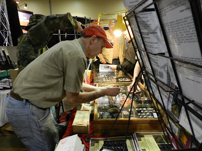
Figure 2. Author Tom Bohmker has spent a fascinating career in the western mining industry.A couple years ago, Tom faced some medical issues that put him in the hospital, weakened with Guillain-Barre Syndrome, a serious disorder where the immune system starts attacking the nervous system. While recovering, he daydreamed about his favorite dredging experiences, and kept coming back to a stint on the Illinois River in southern Oregon.
He eventually wrote the daydreaming episode up in a short story he calls “Snake Oil,” excerpted and lightly edited below:
“We were slowly uncovering bedrock on the Illinois River in southern Oregon …Finally a thin, flat boulder some 3 feet across was found “cemented” with hard pack gravels to the bedrock. I dredged around it and we hoisted the big boulders out of the hole. It took the whole morning to uncover an area 5 by 7 feet or so on the bedrock . We cleaned up about 3 DWT of flakes and pickers from this activity, found mostly in the reddish yellow pack that was within a couple feet of bedrock. We still had the cemented flat rock to move and dredge underneath. With the water clear, I hammered the cemented gravel around the edge and I could see dozens of little flakes of gold 1 to 3 mm in size swirl into the nozzle. I tried driving a gad bar (similar to a carpenter cat’s paw nail-puller) under the flat boulder to shake it loose…it seemed to be held tight with super glue. Again I circled the perimeter hammering the thin layer of cementing gravel. ...
For some 10 minutes I hammered and hammered; finally a little cloud of gray material rose around the boulder signaling it had finally loosened up. I was able to lever it off its perch and the hole became immersed in a cloud of gray. It took a long minute or two for the water to clear and I was anxiously hoping to see some gold. As soon as the dredge started to suck away the thin layer of sand and gravel I could see hundreds of flakes of gold like stars shining on a mountain night. Most of the flakes were large enough to stay on #20 mesh screen or 2 to 3 mm in size and there were hundreds of them. I recall thinking “If this keeps up we’ll get rich.” Of course the “hot spot” was over in just 5 minutes. We cleaned up the sluice again and were thrilled with over 9 DWT (nearly ½ oz. troy).
Still, he lingered in the hospital for several months, until a “golden cure” arrived when his friends brought in the perfect antidote to his doldrums – a full sample jar, crammed with placer gold. “Every day for months the doctor had come in and poked and held my feet hoping to see some nerve reaction or movement. Basically nothing in the feet had changed…they seemed to be immobile. However my mining friend Tom Quintal and his assistant “Professors of Universal Healing” wanted to try to revive my limp lower body. Although Tom was not wearing a dark cape and stove pipe hat, he did ceremoniously wave his bottle of newly mined Briggs Creek Gold under my nose. Wow, did it look good! With difficulty I was able to hold the bottle and examine the heavy flakes and small nuggets and hear them rattle in the bottle. I seemed to feel a wave of energy flow from the hands, into my abdomen then towards the feet. Gold Fever again was evident in my weak and wasted body. I was really excited and felt much better.”

Figure 3. Author Tom Bohmker inspecting a lode sample brought in at the gold show.
Future Plans
Bohmker was nearly half-done with a large work tentatively titled Gold Panner's Guide to California's Klamath Mts. before he had to slow down. He told me that he does have another work in progress: “Along with Eddie Humbird (a real good dredger and pocket hunter in John Day) we may come out with Gold Panner's Guide to Eastern Oregon soon.” It would be a quick, short work, but he still has many mining stories he hopes to get written down.
I asked Tom one of those Robert Service-type questions – was he happier working a single area continuously, or did he have the wanderlust that kept him searching? “In the past, I enjoyed just working a decent spot,” he admitted. “I spent eight years on one set of claims, including whole summers on a single, 150-foot section that was deep and rich, with plenty of good dredging spots. These were economic mining times, when the scale weight at end of the day or week was very important. However, at times I have done weeks on surveys of panning under every bridge...In 15 minutes, if I did not have good color I moved on. That was lots of fun! For example, I tried to pan every major gold stream in the Black Hills...Gold weight was not important. It was the adventure of finding color here and there.”
Field Testing the BookI ‘test-drove’ the Oregon book immediately after leaving the show, dragging a couple helpers out to the Little North Fork of the Santiam River. We followed his directions precisely, and even though the water was still high in late March, we came home with extensive black sand and some decent colors. More importantly, we scouted out camping spots, bedrock, natural riffles, and giant cracks replenished each spring, and just where he said they were. Filing that one away for later in the summer, I immediately began planning a second trip to a spot in the Washington book, just northwest of Mt. St. Helens.
I’d been rockhounding up McCoy Creek several years earlier, searching for perfect little pyrite cubes in a wet clay in the banks of the creek. The bushwhack down was a chore, but I put the spot in my book on Washington locales. Later on, GPAA added a claim to their guide, and I was anxious to check it out on a modest, one-day trip. We waited for decent weather, and when the chance finally came, we followed his map all the way in. I knew the water would be far too high to do any decent sampling, so I concentrated on the lode mines he marked.

Figure 4. GPAA claim known as "Mother's Nightmare" is at the end of the arrow for Yellowjacket Creek, and is fed by the lode mines on Camp Creek.
Mining cabin and pyrite-laden drilling cores mark the lode mines that feed McCoy Creek.
Sure enough, I was able to locate the road in and track down the abandoned drilling cores behind the main building. I walked in further and located the caved-in mine entrance, and found further examples of extensive pyrite, chalcopyrite, bornite, and perhaps arsenopyrite. Needless to say, I went home happy. So based on meeting Tom, testing two pages from his books, and reading the republished information he provides for areas he hasn’t visited, I heartily recommend both books covered here.
Tom will be the first to admit he took more science than English in school. His publisher would do well to employ an editor, and some graphics help on the maps is also in order. But the charm of this book easily overcomes the complaints of an old writing teacher or a former geography student. Tom’s writing shines through when he relates stories about the camps, about lone prospectors who persevered or resilient men who overcame countless obstacles. His energy and enthusiasm burst from the pages, and if you’re lucky enough to be exploring a region Tom knows well, get your order in. It would be best if you could personally take Tom along, but having his book is a darned good substitute.
Garret Romaine is the author of Gem Trails of Oregon, Gem Trails of Washington, and Rockhounding Idaho. He has contributed as a columnist to GPAA Magazine for 15 years. You can find him on Facebook or email him at gromaine3@comcast.net.


